

Validating Terra-i in the Peruvian Amazon


During the 1st and 12th of June 2015, the Terra-i team, together with the Instituto de Investigaciones de la Amazonía Peruana (IIAP) and the Universidad Nacional Agraria La Molina (VLIR-UNALM), conducted the second field validation of the data produced by the Terra-I system. This time, the study area was the Yurimaguas district, Alto Amazonas province, Loreto region (Peru). We used information on populated places, main roads, rivers and information on land cover changes detected for 2013, 2014 and 2015 to define the 65 sampling points (or Terra-I pixels) for the validation process (Figure 1).
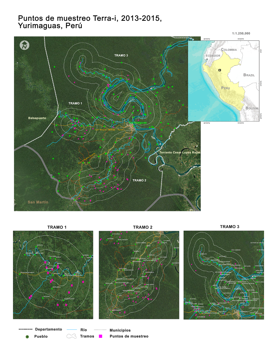
Figure 1. The upper map shows the area of study in Yurimaguas, divided into three sections, each with the buffer area of 1, 3, 5 km around roads and rivers. It also depicts the sampling points of our field work and towns within the district. The maps at the bottom highlight each section of study.
We visited these selected points by road, river and even air (yes, we flew over a part of the study area). We started by road dividing our group in two: the first group composed by Reynaldo Solis from IIAP, Paula Paz from the Terra-I team, and Pedro Ramirez, and the second group composed by Ruben Coppus from CIAT, Jhon Tello from the Terra-I team, and Eduardo Fasabi. On the third day of our visit, the group composed by Ruben and colleagues started a trip of four days along the Huallaga River. The last three days of our field work and under the framework of the technological and knowledge transfer agreement between the DIGOT-MINAM and Terra-I CIAT, we had Witman Garcia and Eloy Valencia accompanying our activities. Additionally, in order to reach various sampling points with difficult access by road or river, we took a small plane and flew over the area for one hour approximately. During our trip we could enjoy the beauty of the landscapes, the local biodiversity, good food, and friendly and generous people always keen to help (Figure 2).
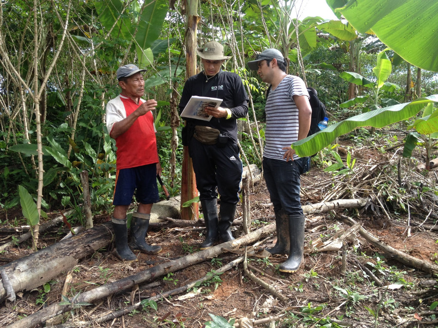
Figure 2. Members of the team conducting a survey.
Study area
The selected study area is in the Yurimaguas district (Alto Amazonas province, Loreto region, Peru). The land cover loss of the district for the period between 2004 and April 2015 is 25869 Ha, with an annual rate of 2156 Ha/year according to the measurements obtained via the Terra-I system. We used the data for years 2013, 2014, and 2015 for the field validation, finding 5081 ha of land cover loss detected through Terra-I (Figure 3).
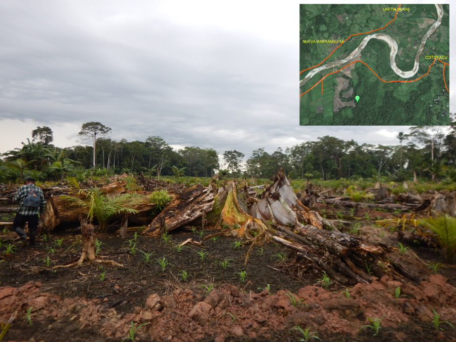
Figure 3. Recent forest clearance for maize and palm oil cultivation.
The economy in Yurimaguas is based in agriculture, livestock raising and forestry. The major products from the region are: palm oil, rice, cassava, yellow maize and starchy bananas (or plantains). The most extended activity is subsistence agriculture, however palm oil cultivation has been dramatically growing during the last couple of years, reaching an extension of 11662 ha and a production of 107230 tonnes for 2014. Likewise, 870 Has have been established with cacao during the last four years. Livestock raising is focused in cattle ranching, porcine husbandry and poultry, mainly.
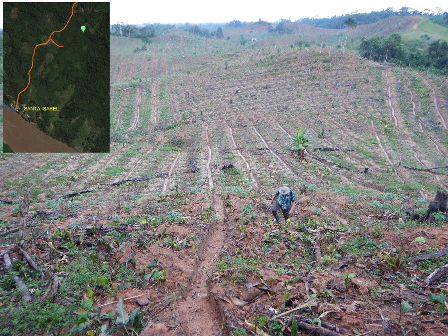
Figure 4. Papaya cultivation, sown by March 2015 near the village of Santa Isabel.
Methodology
Three buffer areas of 1, 3, and 5 km were estimated surrounding roads and main rivers in the region (Figure 1). We defined three paths to visit: 1) using the road that connects Yurimaguas with the town of Munichis, 2) following the road to the town of Grau, and 3) throughout the Huallaga River. We measured the density of Terra-I detection pixels in the region for each year, and for each buffered distance, and afterwards randomly selected the pixels for the field validation, to guarantee the criteria of giving all pixels the same probability of being selected (Olofsson et al., 2014).
Based on the methodology on best practices for land use change studies from IPCC (2013), we estimated a subsample of nine points within each pixel, assuming that a detected change might only occur in a partial section of the pixel (a Terra-I pixel measures 250 x 250 meters, equivalent to 6.25 Ha) (Coca et al., 2014) (Figure 5).
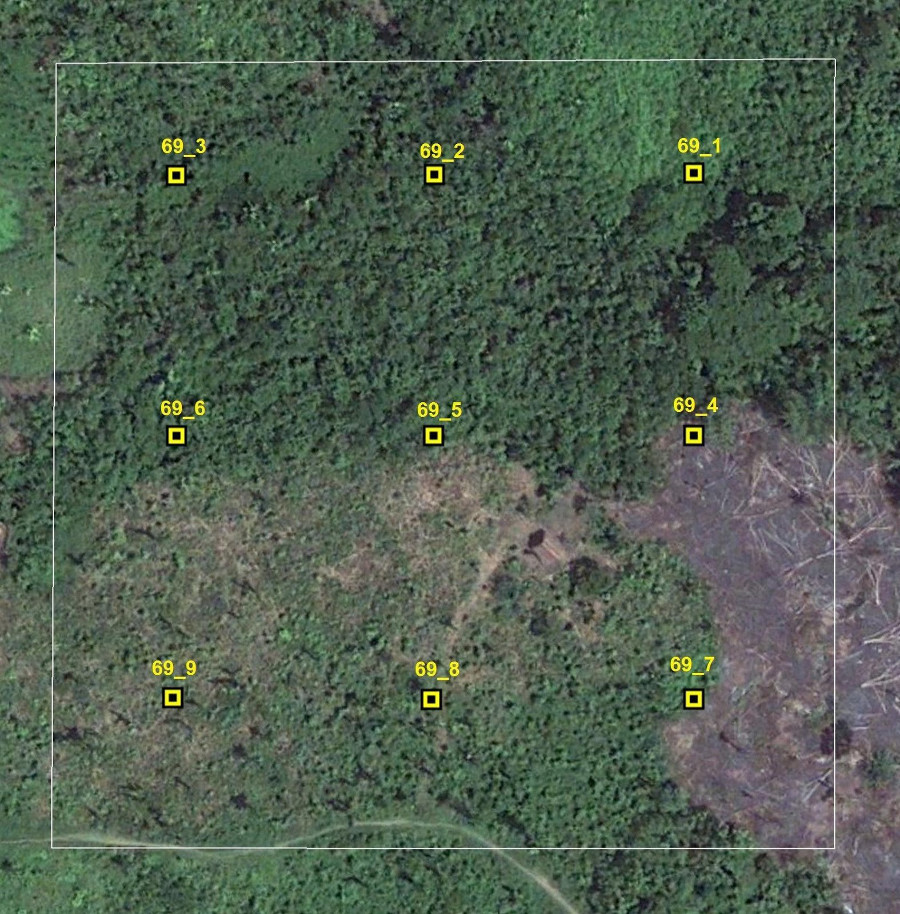
Figure 5. Adaptation of the IPCC methodology (2003) for assessing land use changes within 6.25 has.
We took notes from each of the visited sites, describing whether there are or not changes in the land use, the current type of land cover, species found, and current land use. Moreover, we took pictures on each sub-sampling site on the four cardinal directions (N, E, S, W). We also surveyed local participants at each sampling area when possible.
Preliminary results
According to our observations, we could detect a pattern of accelerated land use change in the areas close to roads due to the growing number of paved roads and secondary pathways. Most of the changes near roads are associated to palm oil cultivation, even reaching an extension above 2000 Has in the case of plantations owned by private companies. Other crops and livestock for milk and meat were identified in smaller extensions owned by local farmers. Milk and meat are locally sold in Yurimaguas and Munichis.
We also identified patches of 40 to 50 Has approx. in pastures and multiple rice plantations of 30 to 50 has, located in the floodplains of the rivers, and close to the commercial routes to Yurimaguas, Iquitos and San Martin. Small cultivations of palm heart, maize, plantain, cassava and peanut were also found in smaller areas.
Cultivations of papaya of about 20 to 40 Has were recorded over the Huallaga River, close to the populated places of Mondongo, Cachihuañusca, Rosa de América, San José de Zapote, Santa Isabel, Jeberillos and 4 de octubre. The papayas produced at these places are sent and commercialized in Lima, Chiclayo and Chimbote. Pastures of 20 – 40 Has with livestock for milk and meat were also seen throughout the edges of the river, and the commercialization of the products derived from this activity takes place locally in Yurimaguas and Iquitos. Plantains and cassava grown in this area are for local consumption.
Finally, during our flight over the study area, we reached sampling points that were not accessible by road neither rivers, most of these sampling points are found within palm oil cultivations (Figure 6).
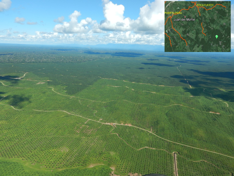
Figure 6. Aerial photo of a palm oil cultivation.
Preliminary conclusions
The population growth in the area of study has created an increasing demand of land for subsistence agriculture, and more recently for commercial agriculture. Areas highly accessible by roads and rivers are being sold by smallholders to large private companies, or to switch their current crops into high value crops, as it is the case of palm oil. Relicts of primary forest are still found within these areas, and under great threat of disappearing.
The field validation of Terra-i data helps us to calibrate our methodologies and therefore improve the precision of our results. This is translated into better decision making for protecting our forests.
We acknowledge all the people that made possible this field work.
References
Olofsson, P., Foody, G. M., Herold, M., Stehman, S. V., Woodcock, C. E. & M. A. Wulder. 2014. Good practices for estimating area and assessing accuracy of land change. Remote Sensing of Environment 148, 42–57.
Coca-Castro, A. 2014. Reporte de la validación en campo del Sistema Terra-i (CIAT) en las comunidades del proyecto ASSETS en la región de Ucayali, Perú. 53 P. En: http://goo.gl/noQsYd
IPCC - Intergovernmental Panel on Climate Change. 2003. Good Practice Guidance for Land Use, Land-Use Change and Forestry. 590 p.
Check more pictures of our field work here: https://www.flickr.com/photos/131075783@N02/albums
Written by: Jhon Jairo Tello, Paula Andrea Paz y Reynaldo Solis. This work was undertaken as part of the project “Sustainable Amazonian Landscapes” which is supported by the International Climate Initiative (IKI). The project is led by CIAT and implemented together with the Potsdam Institute for Climate Impact Research (PIK), the Center for Research on Sustainable Systems of Agriculture Production (CIPAV), Instituto Amazónico de Investigaciones Científicas SINCHI, Universidad de la Amazonía, Instituto de Investigaciones de la Amazonía Peruana (IIAP), and Universidad Nacional Agraria La Molina (VLIR-UNALM).
English version prepared with help of Nora Castañeda (CIAT).


The Terra-i team together with CRS El Salvador under the Raices project carried out a virtual workshop through the teams platform to technicians from the Ministry of Environment and Natural Resources, CARITAS, Universidad El Salvador, CENTA, about the Mapping of land cover using remote sensors and open source tools such as GEE, SEPAL and QGIS- Plugin Semi Automatic Classification.


Near real-time vegetation loss detection in Southwestern Ethiopia: calibration, validation, and implementation of the Terra-i system


The Alliance of Bioversity International and the International Center for Tropical Agriculture (CIAT) (the Alliance) conducted a training for local stakeholders on the use of Terra-i as part of the collaboration with the Netherlands Development Organisation – SNV in the Coffee Agroforestry and Forest Enhancement for REDD+ (CAFÉ-REDD) Project.


From May 8-12, 2017, the Terra-i team, together with staff from the DGOTA of Peru's Ministry of Environment, carried out the first field validation of vegetative land cover changes detected during Terra-i monitoring for 2016 and 2017, using the technology UAV. This work was carried out under the framework of the project “Sustainable Amazonian Landscapes”. The team carried out over-flights with a Phantom 3 advanced rotor drone and a fixed-wing Ebee drone in seven townships of Yurimaguas. The objective of this work was to recognize the dynamics of land cover and land use changes in the region while at the same time to validate the accuracy of the detections of forest loss being monitored by Terra-i in Yurimaguas.


The Terra-i team has worked hard on renovating Terra-i’s website since early this year. A set of new features on the website provides interactive contents and facilitates adaptation to the mobile devices of our users. The fresh website was developed using the latest update of an open-source, Java-based web system, Magnolia CMS 5.4.4. This update was customized to add different categories of interaction such as news, vegetation cover changes, and information, among others.


Globally more than 1 billion people depend on forests for their livelihoods. Forests play a crucial role in climate regulation, ecosystem services provision and regulation, water supply, carbon storage and many other functions that support biodiversity. Currently the global rate of deforestation is substantial, and there is a growing need for timely, spatially explicit data that flag natural vegetation changes due to human activities.


The latest update of Terra-i has been used with the Co$ting Nature ecosystem services assessment tool to understand the impacts of recent forest loss in Colombia on biodiversity and ecosystem services.