

CIAT organizes Terra-i training for provincial officers to monitor vegetation loss and land use change in Lam Dong Province


The Alliance of Bioversity International and the International Center for Tropical Agriculture (CIAT) (the Alliance) conducted a training for local stakeholders on the use of Terra-i as part of the collaboration with the Netherlands Development Organisation – SNV in the Coffee Agroforestry and Forest Enhancement for REDD+ (CAFÉ-REDD) Project.
The project uses Terra-i, a near real time monitoring system for natural vegetation loss detection and land use change in Lac Duong district, Lam Dong province to reduce deforestation and forest degradation in Lang Biang landscape. This project comes after a successful pilot of a UN-REDD supported project that used Terra-i (version 3.0) in monitoring forest conversion to coffee plantation using real-time data in Di Linh district, Lam Dong province.
As part of the capacity building for the project, the first training of provincial officers on operation and use of Terra-i to support near real-time forest cover monitoring in Lac Duong district was held last 24 February-06 March 2020 at the the Alliance Asia Hub in Hanoi. The training participants are composed of five technical officers from Forest Protection Department (FPD) of Lam Dong province, Lac Duong district, Bi Doup Nui Ba National Park, Da Nhim Forest Management Board, and a consultant from farm mapping using drones package of Café-REDD.
The 10-day intensive training covered all the steps to operate Terra-i version 3.0—covering bases from installation, project management, satellite image download, pre-processing, multi-image analysis for detecting changes, to interpreting results. At the end of the training, the participants were able to execute the operational steps of Terra-i version 3.0 and they were able to run the system and produce change detections for a small interested area in Lam Dong province.
Use of near-real time data on vegetation loss
To detect near real-time vegetation loss and gain resulting from human activities, Terra-i provides information about land use change with a frequency and spatial resolution relevant for decisions makers. The latest version (version 3.0) uses high resolution (10m) satellite images from Sentinel-1/2 and Landsat 8 datasets to detect small-scaled changes at district level. This is a major focus for further development of the Terra-i system to become more applicable to current practices and location conditions, including the integration of higher resolution imagery. Employing the latest version Terra-i fitted with customizations to meet the needs and conditions of Lac Duong district can detect vegetation loss up to 100 square meters and send alerts every 12 days. Detected forest loss areas are ranked in terms of priority:low, medium, and high, based on size of the detections and forest origin. The alerts will help equip local forest monitoring and governance stakeholders (e.g. forest owners, local residents, community and authorities, forest protection officers, Provincial Department of Agriculture and Rural Development, etc.) with timely information on land use change and forest loss, to implement proper and timely response.
The first batch of change detections has been released in February 2020 for Lac Duong district with time series satellite imagery dated from March 2015 to January 2020. All the data with detailed information of the detections including locations, forest cover types, forest owners, level of priority, date of detection etc. are available in the Terra-i Vietnam website.
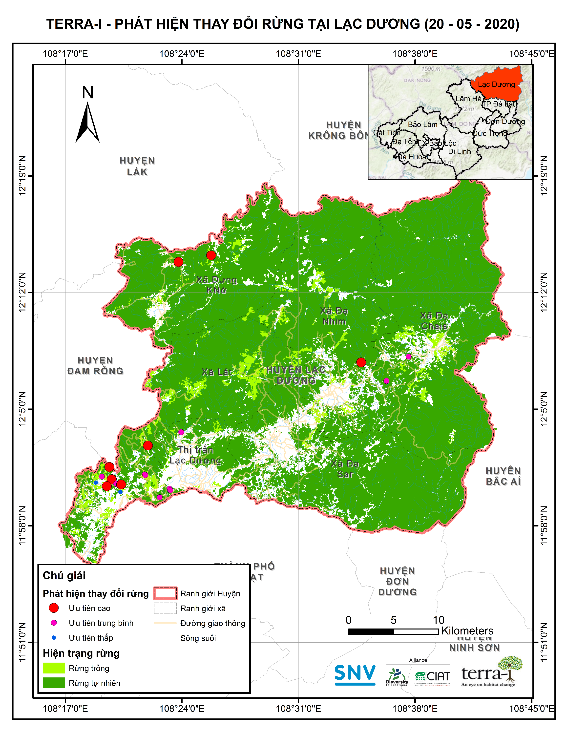
Figure 1. Map of change detections for Lac Duong district
Stakeholder engagement and next steps
Mr. Hoang Van Minh from Lam Dong FPD expressed his impression as a first time Terra-i user. “This is a totally new experience for us. It takes time and effort to master the skills in order to operate the system,” he says, “However, it’s worth it as Terra-i is really useful in providing timely alerts to support our daily task of monitoring forest cover change.”
The team recognized challenges that come with operating the system and discussed that participants need more time to practice and explore the scripts. The need for hardware installation has also been raised as the system requires a high performance computing system to process big data.
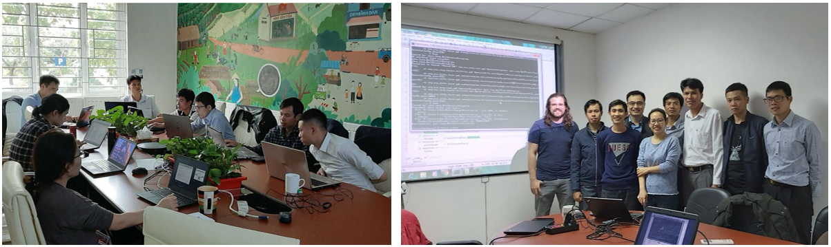
Figure 2. Intensive technical capacity building for provincial officers at CIAT Asia Regional Office in Hanoi
Moving forward, the team is planning to conduct a capacity building workshop for end-users on how to interpret and use Terra-i change detection alerts to support forest monitoring for local actors at district level of Lac Duong. The second period of technical capacity building for provincial officers will also be organized in order to revisit and recall the covered topics, and solve any technical problems encountered in the deployment of Terra-i. Additionally, a capacity building working on using drones to support field validation in combination with Terra-i change detections will be held for local stakeholders.
***
Terra-i is a near real time monitoring system for natural vegetation loss detection and land use change. Terra-i provide maps of vegetation loss areas over the pan-tropical region every 16 days from January 2004. Since June 2012, Terra-i data has been available free of charge for download on www.terra-i.org. It was first implemented in Latin America and is currently implemented in Asia and Africa.
Beside the generation of the data, Terra-i team has used these results in several studies such as identification of areas with high risks of deforestation in the near future, road impact assessment, protected areas effectiveness assessment, trends and rates analysis and many more. All these results and literature are available on Terra-i website.
|
Contact: |
Louis Reymondin, Terra-i team leader (l.reymondin@cgiar.org) |
|
|
Thủy Nguyễn, Terra-i coordinator in South East Asia (thuy.nguyen@cgiar.org) |
|
Address: |
International Center for Tropical Agriculture (CIAT) Agricultural Genetics Institute Pham Van Dong Road (opposite to Ministry of Public Security), Bac Tu Liem District, Hanoi, Vietnam |


The Terra-i team together with CRS El Salvador under the Raices project carried out a virtual workshop through the teams platform to technicians from the Ministry of Environment and Natural Resources, CARITAS, Universidad El Salvador, CENTA, about the Mapping of land cover using remote sensors and open source tools such as GEE, SEPAL and QGIS- Plugin Semi Automatic Classification.


Near real-time vegetation loss detection in Southwestern Ethiopia: calibration, validation, and implementation of the Terra-i system


IDENTIFICACIÓN DE CAUSAS DE PÉRDIDA DE COBERTURA VEGETAL EN LAS ÁREAS DE INTERVENCIÓN DE LA ACTIVIDAD GOBERNANZA EN ECOSISTEMAS, MEDIOS DE VIDA Y AGUA (USAID/GEMA) EN EL OCCIDENTE DE HONDURAS


MAPEO DE COBERTURAS DE LA TIERRA PARA EL 2017, EN EL OCCIDENTE HONDUREÑO SOBRE ÁREAS DE INTERVENCIÓN DE LA ACTIVIDAD GOBERNANZA EN ECOSISTEMAS, MEDIOS DE VIDA Y AGUA (USAID/GEMA)


CUANTIFICACIÓN DE LA DEFORESTACIÓN EN LAS ÁREAS DE INTERVENCIÓN DE LA ACTIVIDAD GOBERNANZA EN ECOSISTEMAS, MEDIOS DE VIDA Y AGUA (USAID/GEMA) EN EL OCCIDENTE DE HONDURAS


An international team of scientists*, involving entomologists, conservation biologists, agro-ecologists and geographers, has just revealed how on-farm insect biological control can slow the pace of tropical deforestation and avert biodiversity loss on a macro-scale. The case study concerns biological control of the invasive mealybug Phenacoccus manihoti with the introduced host-specific parasitic wasp Anagyrus lopezi in Southeast Asia. The results of this study have just been published in Communications Biology – Nature.


From May 8-12, 2017, the Terra-i team, together with staff from the DGOTA of Peru's Ministry of Environment, carried out the first field validation of vegetative land cover changes detected during Terra-i monitoring for 2016 and 2017, using the technology UAV. This work was carried out under the framework of the project “Sustainable Amazonian Landscapes”. The team carried out over-flights with a Phantom 3 advanced rotor drone and a fixed-wing Ebee drone in seven townships of Yurimaguas. The objective of this work was to recognize the dynamics of land cover and land use changes in the region while at the same time to validate the accuracy of the detections of forest loss being monitored by Terra-i in Yurimaguas.


CIAT and the Terra-i team are pleased to announce the publication of a new study in Paraquaria Natural, the most prestigious journal in Paraguay dedicated to biodiversity and the conservation of nature.


The Terra-i team has worked hard on renovating Terra-i’s website since early this year. A set of new features on the website provides interactive contents and facilitates adaptation to the mobile devices of our users. The fresh website was developed using the latest update of an open-source, Java-based web system, Magnolia CMS 5.4.4. This update was customized to add different categories of interaction such as news, vegetation cover changes, and information, among others.


Globally more than 1 billion people depend on forests for their livelihoods. Forests play a crucial role in climate regulation, ecosystem services provision and regulation, water supply, carbon storage and many other functions that support biodiversity. Currently the global rate of deforestation is substantial, and there is a growing need for timely, spatially explicit data that flag natural vegetation changes due to human activities.
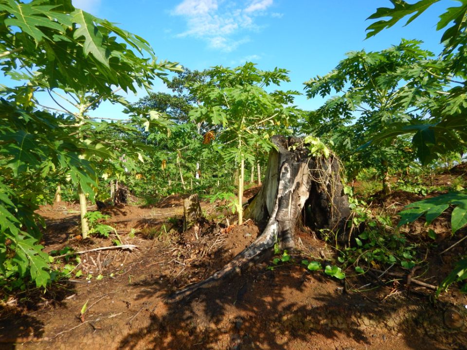

New deforestation hotspots point the finger at my favourite fruit I love Terra-i, but today I hate it. A lot. The system uses satellite images to track deforestation in the Amazon in near-realtime. It’s extremely accurate: if a bunch of trees come down somewhere – no matter how remote – Terra-i picks it up. Cool, right? Not today. CIAT’s Louis Reymondin, the system’s chief architect, dropped the bombshell over coffee: it looks as though hundreds of hectares of rainforest in Peru are being trashed by… papaya.


The latest update of Terra-i has been used with the Co$ting Nature ecosystem services assessment tool to understand the impacts of recent forest loss in Colombia on biodiversity and ecosystem services.


The production of geospatial data related to land-use and land cover changes by governments and civil society organizations has vastly increased during the last decade. Going beyond the valuable information (location, rates and absolute values of changes) provided by these datasets, it is important to have a better understanding of the spatial configurations and composition of the detected change areas at multiple spatial resolutions and time periods. Alejandro Coca-Castro’s research is aiming to map types of spatial deforestation patterns in the Amazon rainforest through the integration of landscape fragmentation metrics and data mining techniques. The research will contribute to the understanding of two deforestation datasets (Terra-i and GFC) and is part of his master dissertation at King’s College London. This blog post highlights Alejandro’s research methodology, preliminary findings and challenges.


Ecuador is recognized as one of the biodiverse hotspots on earth, underneath the Amazon rainforest lies the country’s oil reservoir. With the oil companies and cleared routes come settlers, therefore more and more of this diverse rainforest is being cut down. Since the oil concerns entered the Ecuadorian Amazon 45 years ago, they keep exploring and exploiting the area. The Terra-i detections reveal a total habitat loss of 87,525 Ha, 16,943 Ha (19%) is part of protected areas, between January 2004 and February 2015.
The Terra-i team together with CRS El Salvador under the Raices project carried out a virtual workshop through the teams platform to technicians from the Ministry of Environment and Natural Resources, CARITAS, Universidad El Salvador, CENTA, about the Mapping of land cover using remote sensors and open source tools such as GEE, SEPAL and QGIS- Plugin Semi Automatic Classification.
Near real-time vegetation loss detection in Southwestern Ethiopia: calibration, validation, and implementation of the Terra-i system
From May 8-12, 2017, the Terra-i team, together with staff from the DGOTA of Peru's Ministry of Environment, carried out the first field validation of vegetative land cover changes detected during Terra-i monitoring for 2016 and 2017, using the technology UAV. This work was carried out under the framework of the project “Sustainable Amazonian Landscapes”. The team carried out over-flights with a Phantom 3 advanced rotor drone and a fixed-wing Ebee drone in seven townships of Yurimaguas. The objective of this work was to recognize the dynamics of land cover and land use changes in the region while at the same time to validate the accuracy of the detections of forest loss being monitored by Terra-i in Yurimaguas.
The Terra-i team has worked hard on renovating Terra-i’s website since early this year. A set of new features on the website provides interactive contents and facilitates adaptation to the mobile devices of our users. The fresh website was developed using the latest update of an open-source, Java-based web system, Magnolia CMS 5.4.4. This update was customized to add different categories of interaction such as news, vegetation cover changes, and information, among others.
Globally more than 1 billion people depend on forests for their livelihoods. Forests play a crucial role in climate regulation, ecosystem services provision and regulation, water supply, carbon storage and many other functions that support biodiversity. Currently the global rate of deforestation is substantial, and there is a growing need for timely, spatially explicit data that flag natural vegetation changes due to human activities.
The latest update of Terra-i has been used with the Co$ting Nature ecosystem services assessment tool to understand the impacts of recent forest loss in Colombia on biodiversity and ecosystem services.


During the 1st and 12th of June 2015, the Terra-i team, together with the Instituto de Investigaciones de la Amazonía Peruana (IIAP) and the Universidad Nacional Agraria La Molina (VLIR-UNALM), conducted the second field validation of the data produced by the Terra-I system. This time, the study area was the Yurimaguas district, Alto Amazonas province, Loreto region (Peru). We used information on populated places, main roads, rivers and information on land cover changes detected for 2013, 2014 and 2015 to define the 65 sampling points (or Terra-I pixels) for the validation process (Figure 1).