
Transcending distance: successful Terra-i webinar


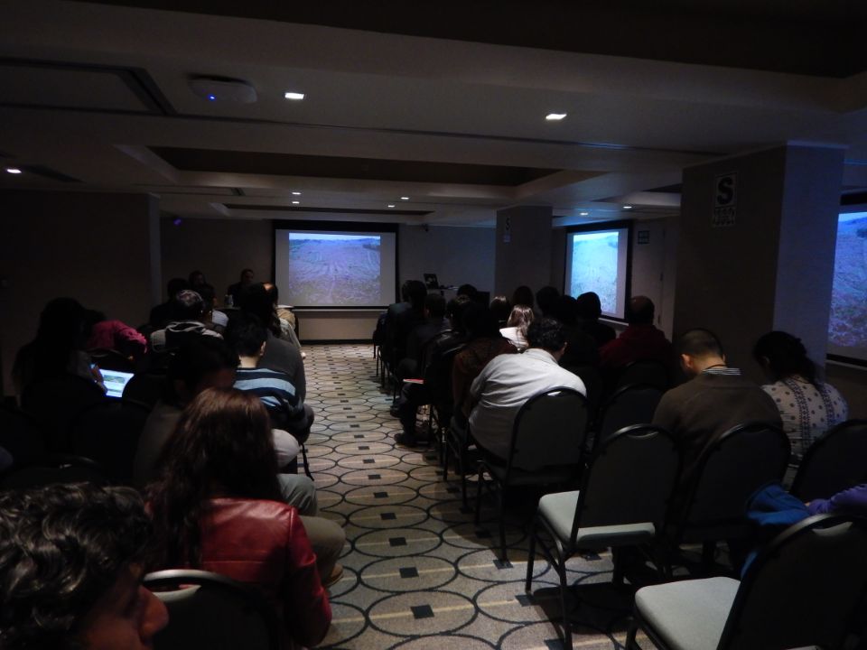
Last Wednesday, January 29, Terra-i reached an important milestone in developing capacities. Of 785 registered, more than 450 people successfully participated in the 1st Terra-i webinar. During approximately 1 hour the principal characteristics and advances of the tool were described. Also a demonstration of the use of the data was shown, ending with a question and answer session and the words of Glenn Hyman about the importance of this effort.
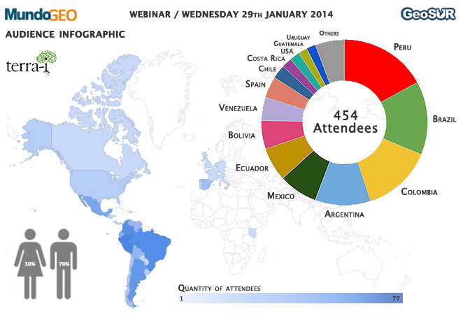
Figure 1. Infographic that indicates the gender (left), spatial distribution (map) and the participation of the countries with the majority of participants (greater than 8) in the webinar.
The 1st Terra-i webinar was successfully carried out with the support of MundoGEO, one of the most widely read portals on the topic of geospatial technologies, GeoSUR, a spatial information network for Latin America and the Caribbean and the Development Bank of Latin America (CAF).
DAPA-CIAT researchers Louis Reymondin, Alejandro Coca and Glenn Hyman represented the work of the Terra-i initiative. Alejandro and Louis explained methodological aspects and advances of the project for the audience in both Spanish and English. They also demonstrated how to access, use and interpret the data. Glenn ended the webinar describing his experience in the use of the data of for monitoring natural vegetation. Glenn emphasized the easy access, the potential use of the data and the free access policy provided by Terra-i. Finally, he called for users of the tool to create more spaces for discussion among the community of users.
Webinar (2014/01/29) | Terra-i: datos libres para el monitoreo de cobertura natural de América Latina y el Caribe from MundoGEO on Vimeo.
Knowing the audience…
People from 27 countries around the world participated in the webinar. The large majority of attendees were from the Latin American region, with more than 50% from Peru, Brazil Colombia and Argentina (Figure 1). Regarding gender, almost 30% of the audience were women.
The questions sent to the webinar site allowed us to understand a little more about the type of audience (Figure 2). For example, the majority of the participants already knew of the Terra-i initiative (70%) and also were users of GIS (95%). When users were asked about their knowledge of natural vegetation monitoring systems in their countries the response was divided between yes (26%), no (35%) and don’t know (39%).
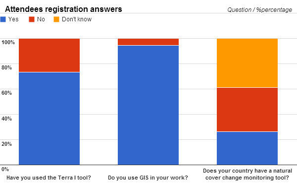
Figure 2. Results of questions sent to the will webinar organizers.
Monitoring events in our network….
Online interaction spaces with the users are an excellent communication channel as was shown by new users to our webpage. Since the announcement of the webinar (January 23) to the final day of this month (January 31) 160 new users were registered, including 80 new users on the day of the webinar (January 29)
Regarding the quantity of visits to the website, about 380 were made on the day of the webinar, a total of 1200 or 120 visits per day since the announcement at the end of January. This value is twice the average since the launch of our website in February 2012.
Finally, an increase in traffic among our social networks was also recorded. Although not as significant as traffic on a website, there are to date 321 “likes” on our Facebook page, 115 followers in Twitter and 23 subscribers to our YouTube page.
And uncertainties that open new doors and help us improve …
Although this webinar was only limited to 6 questions after the demonstration, another 40 questions were raised and will be answered according to their relevance in the section of our webpage on frequently asked questions (FAQ). These questions suggest new opportunities and also elements of our initiative that can be improved. Below, we share 3 questions that showed different uncertainties and possible profiles of the participants.
Technical
Q: What is the validation, how is it measured? by Jesús Anaya, Colombia
A: To calculate validity, we compare our results with other systems (for example PRODES in Brazil) and we calculate indices such as precision, the recall and the kappa index (see Annex 2 of the land-use report in the publications section). We are also organizing validation results from fieldwork in Ucayali, Peru.
Non-technical
Q: Good morning, I would like to know if the results from the studies are available in the Terra-i website. Also, I would like to know if it is possible to contact somebody to know more about the methodology. Finally, if we are interested in requesting some training how would we do that? Thank you! By Anggela Michi, Peru
A: The majority of the studies that we or our partners have conducted are in the publications section on the website. For more information about the methodology or to request training you can contact us at the email address: terra.i.ciat@gmail.com.
Web portal
Q: Can I link Terra-i to my map server? By Raúl Molina, Bolivia
A: At the moment we do not have a web service to directly share data with other servers, but you can link to our website. In the near future we will include such a service.
The Terra-i team is grateful to all interested colleagues and to participants in this webinar. As well we would like to thank MundoGEO and GeoSUR for providing this opportunity to interact with colleagues. We would also like to thank our colleagues in the CGIAR Research Program on Forestry, Trees and Agroforestry (FTA), The Nature Conservancy, King's College London (KCL), HEIG-VD and others who have supported this initiative.
Blog post by Alejandro Coca. Translation and revision of English-language version by Glenn Hyman (CIAT researcher).


The Terra-i team together with CRS El Salvador under the Raices project carried out a virtual workshop through the teams platform to technicians from the Ministry of Environment and Natural Resources, CARITAS, Universidad El Salvador, CENTA, about the Mapping of land cover using remote sensors and open source tools such as GEE, SEPAL and QGIS- Plugin Semi Automatic Classification.


Near real-time vegetation loss detection in Southwestern Ethiopia: calibration, validation, and implementation of the Terra-i system


The Alliance of Bioversity International and the International Center for Tropical Agriculture (CIAT) (the Alliance) conducted a training for local stakeholders on the use of Terra-i as part of the collaboration with the Netherlands Development Organisation – SNV in the Coffee Agroforestry and Forest Enhancement for REDD+ (CAFÉ-REDD) Project.


From May 8-12, 2017, the Terra-i team, together with staff from the DGOTA of Peru's Ministry of Environment, carried out the first field validation of vegetative land cover changes detected during Terra-i monitoring for 2016 and 2017, using the technology UAV. This work was carried out under the framework of the project “Sustainable Amazonian Landscapes”. The team carried out over-flights with a Phantom 3 advanced rotor drone and a fixed-wing Ebee drone in seven townships of Yurimaguas. The objective of this work was to recognize the dynamics of land cover and land use changes in the region while at the same time to validate the accuracy of the detections of forest loss being monitored by Terra-i in Yurimaguas.


The Terra-i team has worked hard on renovating Terra-i’s website since early this year. A set of new features on the website provides interactive contents and facilitates adaptation to the mobile devices of our users. The fresh website was developed using the latest update of an open-source, Java-based web system, Magnolia CMS 5.4.4. This update was customized to add different categories of interaction such as news, vegetation cover changes, and information, among others.


Globally more than 1 billion people depend on forests for their livelihoods. Forests play a crucial role in climate regulation, ecosystem services provision and regulation, water supply, carbon storage and many other functions that support biodiversity. Currently the global rate of deforestation is substantial, and there is a growing need for timely, spatially explicit data that flag natural vegetation changes due to human activities.


The latest update of Terra-i has been used with the Co$ting Nature ecosystem services assessment tool to understand the impacts of recent forest loss in Colombia on biodiversity and ecosystem services.


During the 1st and 12th of June 2015, the Terra-i team, together with the Instituto de Investigaciones de la Amazonía Peruana (IIAP) and the Universidad Nacional Agraria La Molina (VLIR-UNALM), conducted the second field validation of the data produced by the Terra-I system. This time, the study area was the Yurimaguas district, Alto Amazonas province, Loreto region (Peru). We used information on populated places, main roads, rivers and information on land cover changes detected for 2013, 2014 and 2015 to define the 65 sampling points (or Terra-I pixels) for the validation process (Figure 1).