
Tracking forest loss on the Guatemala-Belize border


The endemic border dispute between Guatemala and Belize is no longer the unique fuel that drives the two countries’ popularity. Between 2004 and 2010, the Belize districts of Cayo, Orange Walk and Toledo lost 6,375 ha of natural vegetative cover, equivalent to an annual average of 911 ha/year. Across the border, in the Petén department of Guatemala, a total of 95,769 ha of natural habitat were lost, corresponding with an average rate of change of 13,681 ha/year. Terra-i illustrates the contrasting scenarios surrounding deforestation on the Guatemala-Belize border between 2004 - 2010 (Figure 1). This reinforces the findings of the recent NASA study, according to which the highest deforestation rates and changes in natural vegetative cover in the two countries have been identified during 2000-2010.
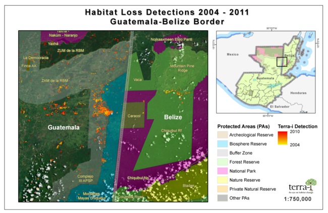
Figure 1. Terra-i land use change detection map, zoomed on deforestation hotspots on the Guatemala-Belize frontier, between 2004-2010 (yellow to red spots).
Belize is one of the world’s most biologically diverse nations and shares the largest proportion of forested area in Central America. In 2010, forests covered approximately 61 % of the country (16,530 sq km). The population density is here the lowest in the entire Central American region and, according to the 2011 Human Development Report, one third of the people have been reported to live below the national poverty line (from a total population of 356,600) . In contrast, Guatemala has only about 31 % of its land area covered by forests (38,300 sq km), facing one of the highest deforestation rates in Central America. Population in the country has doubled since 1985, reaching 14,757,316 in 2011, half of which now lives below the national poverty line.
The first tracking system for habitat loss across Latin America, Terra-i, enabled the analysis of deforestation on the Guatemala-Belize border, in the Petén department (Guatemala) and the three districts – Cayo, Orange Walk and Toledo (Belize), for a period of seven years (2004-2010). Most of the deforestation events that occurred between 2004 and 2010 were located within these administrative areas. Indeed, 85% of the deforestation that occurred in Belize was located within these three districts adjacent to Guatemala. On the other side, 74% of the deforestation rates in Guatemala have been located in the Petén department, which also holds the highest annual rate of population growth in the country.
In the Belize districts of Cayo, Orange Walk and Toledo Terra-i detected a 338 ha loss in 2004 and 1875 ha in 2010 (an increase of 455%). Within the same period, a total of 6,375 ha of natural vegetative cover were lost, which is equivalent to an annual average of 911 ha/year. In the Guatemalan Petén, about 1,569 ha were lost in 2004 and 16,500 ha in 2010 (an increase of 952%). During this time, the registered natural habitat loss equaled 95,769 ha (an average rate of change of 13,681 ha/year). Within the studied areas, 100% of the deforestation events occurred within the Petén-Veracruz moist forest eco-region.
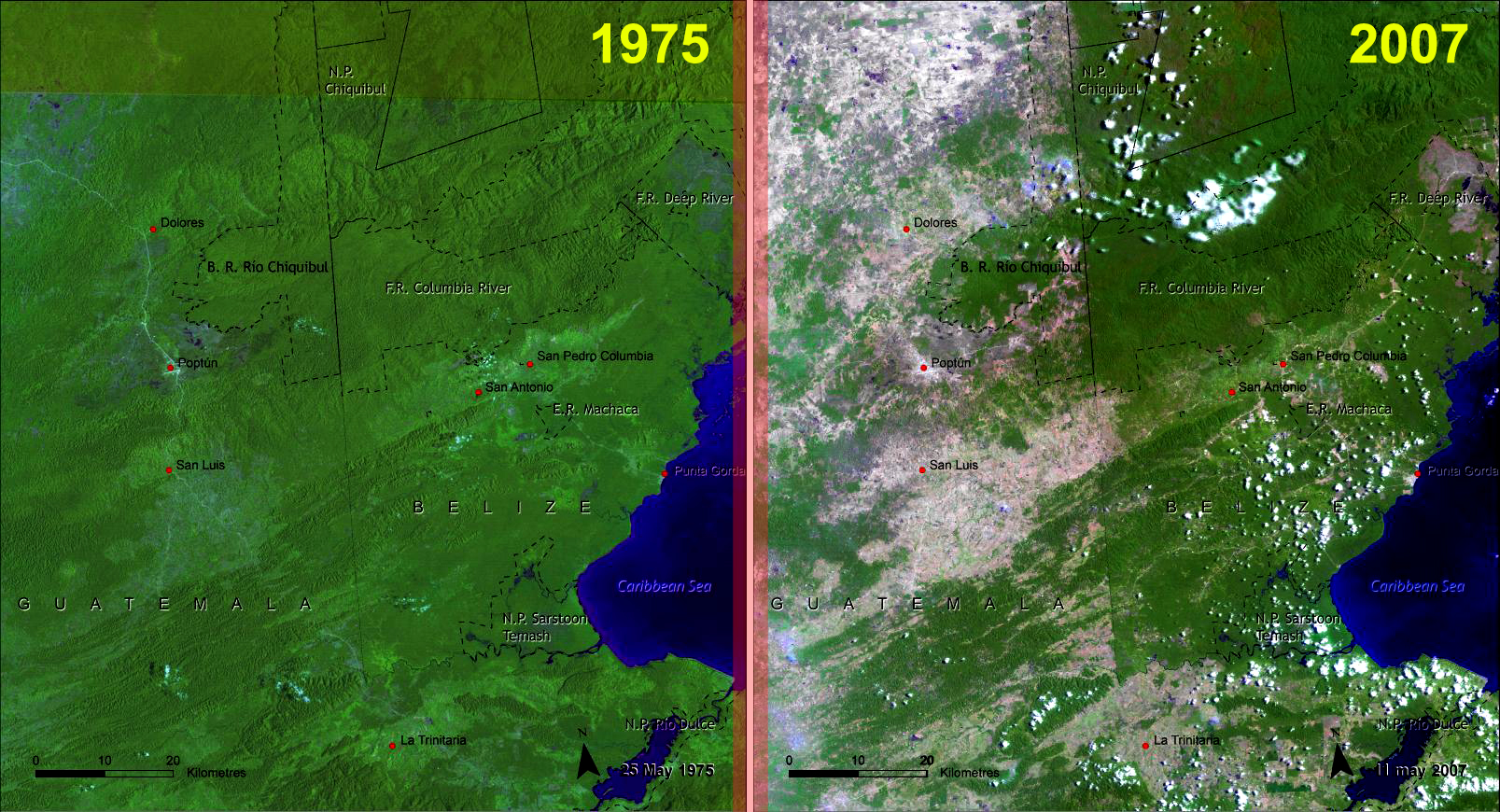
Figure 2. Satellite images provided by NASA show the high landscape change between 1975 and 2007 on the Guatemala-Belize border. Source: UNEP, CATHALAC.
Ciat
Although the analyzed regions are home to a considerable number of protected areas, deforestation rates are still high. In Petén (Guatemala), Terra-i was able to detect strong disturbance events in the protected “Complejo III APSP”, a buffer zone of the Maya Biosphere Reserve. The region, despite being Central America’s largest protected area with high levels of biodiversity, experienced extensive deforestation events which are now advancing towards the Belize frontier. According to Gilles Selleron, a geographer at the University of Toulouse-Le-Mirai, cattle rearing, mainly carried out by the Ladino population (people of Hispanic origin) and traditional subsistence farming of corn, marrow and beans by the indigenous Q'eqchi are the main drivers of deforestation in the Petén department. Also, as the population rate in the country grows the pressure on natural resources increases proportionally with the demand for food, fuel and other resources.
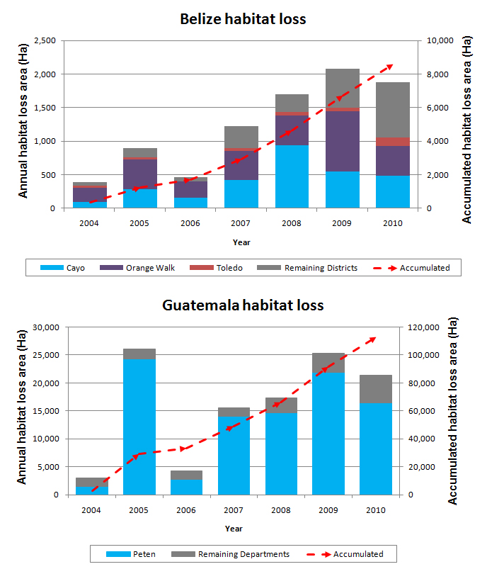
Figure 3. Annual rate of habitat loss and accumulated loss for administrative areas, which are in the both sides of Guatemala-Belize border and the same values for the remaining of each country.
Ciat
Across the border, in Belize, illegal activities (selective logging, timber harvesting, animal and plant poaching and gold mining), increased oil explorations (the majority of potential oil reserves are located within protected areas) and infrastructure improvement projects are the most common threats to the natural habitat. For example, the Southern Highway (Mile 14)- Belize/Guatemala Border Road Project is under construction and will facilitate communication within Belize as well as connections with Guatemala and Honduras. Such infrastructural improvements could increase the risk of negative impact on natural and cultural resources as has already occurred in other places in Latin America, reconfirming the importance of integrating broader road construction projects with comprehensive sustainable development planning.
At the same time, the Chiquibul forest in Belize, the country’s largest protected area, has benefited from a coherent law framework which helped reduce human impact on forested areas. One good example is the Ceibo Chico Protocol, a document signed by the Belize government in cooperation with Friends of Conservation and Development park rangers, B.D.F. soldiers, the Forest Department and Police personnel. This document illustrates government’s effort to put an end to the increasing illegal activities and to protect historical and cultural resources like the Caracol Reserve in western Belize.
Thus, the Terra-i tool proves to be a powerful deforestation-tracker which, combined with information on the drivers and consequences of habitat loss, can help us better understand how and why forest loss occur.
Are you interested in watching the evolution of deforestation in the Guatemala-Belize border? Play the following video: https://youtu.be/MSpN2Jt2mT4
The article was authored by Alejandro Coca, Louis Reymondin and Andreea Nowak, with the support of Caitlin Peterson and Carolina Navarrete Frías (editors).


IDENTIFICACIÓN DE CAUSAS DE PÉRDIDA DE COBERTURA VEGETAL EN LAS ÁREAS DE INTERVENCIÓN DE LA ACTIVIDAD GOBERNANZA EN ECOSISTEMAS, MEDIOS DE VIDA Y AGUA (USAID/GEMA) EN EL OCCIDENTE DE HONDURAS


MAPEO DE COBERTURAS DE LA TIERRA PARA EL 2017, EN EL OCCIDENTE HONDUREÑO SOBRE ÁREAS DE INTERVENCIÓN DE LA ACTIVIDAD GOBERNANZA EN ECOSISTEMAS, MEDIOS DE VIDA Y AGUA (USAID/GEMA)


CUANTIFICACIÓN DE LA DEFORESTACIÓN EN LAS ÁREAS DE INTERVENCIÓN DE LA ACTIVIDAD GOBERNANZA EN ECOSISTEMAS, MEDIOS DE VIDA Y AGUA (USAID/GEMA) EN EL OCCIDENTE DE HONDURAS


An international team of scientists*, involving entomologists, conservation biologists, agro-ecologists and geographers, has just revealed how on-farm insect biological control can slow the pace of tropical deforestation and avert biodiversity loss on a macro-scale. The case study concerns biological control of the invasive mealybug Phenacoccus manihoti with the introduced host-specific parasitic wasp Anagyrus lopezi in Southeast Asia. The results of this study have just been published in Communications Biology – Nature.


CIAT and the Terra-i team are pleased to announce the publication of a new study in Paraquaria Natural, the most prestigious journal in Paraguay dedicated to biodiversity and the conservation of nature.

New deforestation hotspots point the finger at my favourite fruit I love Terra-i, but today I hate it. A lot. The system uses satellite images to track deforestation in the Amazon in near-realtime. It’s extremely accurate: if a bunch of trees come down somewhere – no matter how remote – Terra-i picks it up. Cool, right? Not today. CIAT’s Louis Reymondin, the system’s chief architect, dropped the bombshell over coffee: it looks as though hundreds of hectares of rainforest in Peru are being trashed by… papaya.


The production of geospatial data related to land-use and land cover changes by governments and civil society organizations has vastly increased during the last decade. Going beyond the valuable information (location, rates and absolute values of changes) provided by these datasets, it is important to have a better understanding of the spatial configurations and composition of the detected change areas at multiple spatial resolutions and time periods. Alejandro Coca-Castro’s research is aiming to map types of spatial deforestation patterns in the Amazon rainforest through the integration of landscape fragmentation metrics and data mining techniques. The research will contribute to the understanding of two deforestation datasets (Terra-i and GFC) and is part of his master dissertation at King’s College London. This blog post highlights Alejandro’s research methodology, preliminary findings and challenges.


Ecuador is recognized as one of the biodiverse hotspots on earth, underneath the Amazon rainforest lies the country’s oil reservoir. With the oil companies and cleared routes come settlers, therefore more and more of this diverse rainforest is being cut down. Since the oil concerns entered the Ecuadorian Amazon 45 years ago, they keep exploring and exploiting the area. The Terra-i detections reveal a total habitat loss of 87,525 Ha, 16,943 Ha (19%) is part of protected areas, between January 2004 and February 2015.