
Suriname, a forest wealth country affected by an environmental issue


Suriname, one of the most forested countries in the world is currently impacted by one of the most controversial environmentally-sensitive activities, mining. During the last decade, rising gold prices and consequently its exportation have made gold mining, and the extractive sector, one of the main economic activities for the country. At the same time, a high degree of land cover change due to anthropogenic influences has caused an annual loss rate of approximately 7,499 hectares per year (since 2004 to 2013). The districts of Sipaliwini, Brownsweg and Para have experienced the highest rate of forest loss as well the Brownsberg Nature Park which, according to a recent study by WWF , have presented environmental issues of international concern.
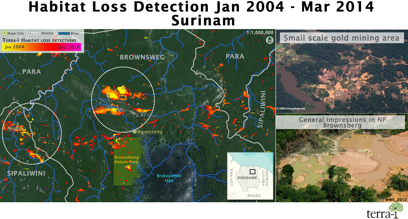
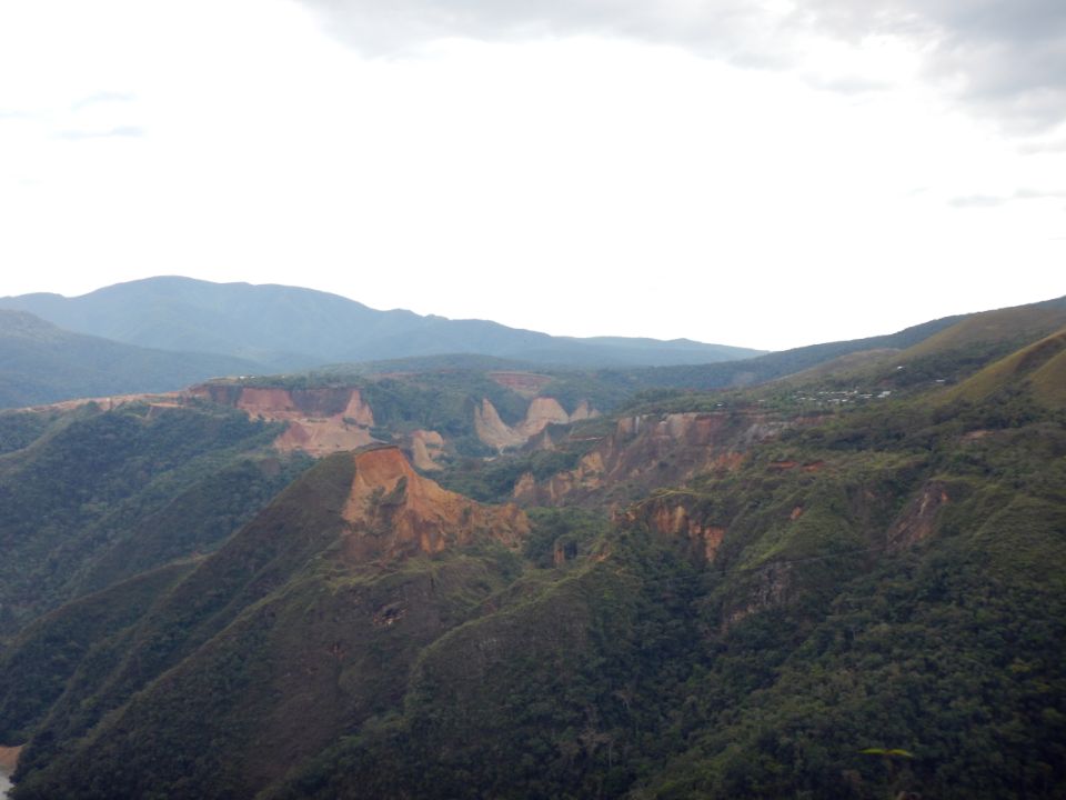
Figure 1.Left, the map of forest cover loss detections by the Terra-i system from January 2004 to March 2014. The main hotspots of deforestation are located in the districts of Sipaliwini, Brownsweg and Para, being mainly caused by the mining activities presented inside the dotted white circles. Right; aerial images taken over these hot spots areas. Pictures sources: Mongabay, WWF Guianas.
About Suriname
Suriname is recognized globally as one the most forested countries. Over 90% of the land cover remains intact as forests; this is around 15 million hectares (Ha), out of which 2.3 million Ha (13% of total forests area) are conservation areas, and another 4 to 5 million Ha have been designated as production forest [1].
Nevertheless, despite its wealth of forest cover, the negative impact from mining industries, the largest sector of the country economy, have been evident, both by illegal (small scale) and legal mining. Although this sector has attracted most of investments (national and international) in the country, and consequently a rising trend of its exportation and the development of related sectors [2], it is also the main cause of the increase in the national deforestation rate. In addition, other change drivers include hydropower construction, agriculture (including slash and burn) and road construction.
The impact of extractive industries under the Terra-i system lens
The impact of the mining industry, especially due to illegal mining, has promoted a high forest cover loss in Suriname during the last ten years. According to the Terra-i system, Suriname has recorded a total forest cover loss of 74,993 Ha (an annual rate of loss of 7,499 Ha/year), showing an increase of 567% for the last two analyzed years (2012 and 2013). From the same 10 years-period, the highest cumulative and annual rates of vegetation loss were found in districts of Sipaliwini (cumulative of 38,894 Ha; or annual rate of 3,889 Ha/year), Brokopondo (cumulative of 20,831 Ha; or annual rate of 2,083 Ha/year) and Para (cumulative of 5,737 Ha; or annual rate of 573 Ha/year).
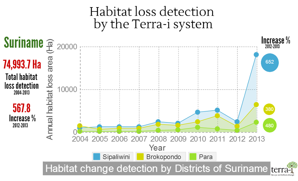
Figure 2. Infographic showing the natural vegetation losses in Surinam and its Districts based on the Terra-i system (version January 2004 - March 2014).
The Brownsberg Nature Park and its environmental context
This national nature park, located in the Brokopondo district in eastern Suriname, is one of the most visited tourist attraction in Suriname. With an area of 12,250 Ha, around 1,000 Ha was designated for artisanal small-scale mining [3]. It is important to highlight that this activity has extended to the boundaries of the park due to different socio-economic and inadequate management factors of the park. A recent study by WWF estimated that 5% of forest cover loss is caused by the artisanal small-scale mining, which is predicted to increase due to the rise of gold prices, and consequently its exportation.
Based on the Terra-i system, the trends of natural cover loss were analyzed in this conservation area during the past ten years. As a result, a cumulative loss of 1,125 Ha is reported, representing an annual rate of 112.5 Ha/year , since 2004 to 2013. In addition, there is an upward trend of vegetation loss in the last three years – as seen from data analyzed from 2011 to date.
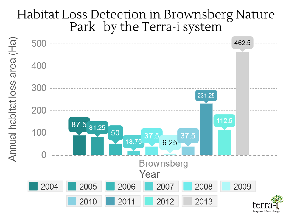
Figure 3. Annual rate of vegetation loss in the Brownsberg Nature Park from 2004 to 2013 according to the Terra-i system (version January 2004 - March 2014).
The current challenge of the country
Currently, Suriname has a global environmental challenge to maintain its reputation as nation of forests. To achieve this, a lot of efforts is required to reorient its economic development in line with strategies that promote low carbon emissions, implement initiatives of sustainable natural resource management, and also strengthen the capacity to adapt to climate change impacts [2]. Finally, it is important to highlight the presence of several initiatives in this country, supported by multiple environmental groups, which have a common approach for managing and conserving its natural resources.
Bibliography
[1] FAO. 2010. The Global Forest Resources Assessment Country Report Suriname. Online [http://goo.gl/6C1bpF]
[2] Conservation International Guyana, Projekt-Consult GmbH,WWF Guianas. 2013. Guyana’s Extractive Industry Sector (EIS). Online [http://goo.gl/hRiXHV]
[3] WWF Guianas. 2012. Brownsberg Nature Park Situation Analysis 2012. Online [http://goo.gl/T0a5kl]
[4] WWF Guianas. 2012. Photo impression of status Brownsberg Nature Park. Online [goo.gl/JZLjtu]
Blog post by Paula A. Paz-Garcia , Alejandro Coca-Castro. Revision of English-language version by Oluwabunmi Ajilore (CIAT / CCAFS visiting researcher).


IDENTIFICACIÓN DE CAUSAS DE PÉRDIDA DE COBERTURA VEGETAL EN LAS ÁREAS DE INTERVENCIÓN DE LA ACTIVIDAD GOBERNANZA EN ECOSISTEMAS, MEDIOS DE VIDA Y AGUA (USAID/GEMA) EN EL OCCIDENTE DE HONDURAS


MAPEO DE COBERTURAS DE LA TIERRA PARA EL 2017, EN EL OCCIDENTE HONDUREÑO SOBRE ÁREAS DE INTERVENCIÓN DE LA ACTIVIDAD GOBERNANZA EN ECOSISTEMAS, MEDIOS DE VIDA Y AGUA (USAID/GEMA)


CUANTIFICACIÓN DE LA DEFORESTACIÓN EN LAS ÁREAS DE INTERVENCIÓN DE LA ACTIVIDAD GOBERNANZA EN ECOSISTEMAS, MEDIOS DE VIDA Y AGUA (USAID/GEMA) EN EL OCCIDENTE DE HONDURAS


An international team of scientists*, involving entomologists, conservation biologists, agro-ecologists and geographers, has just revealed how on-farm insect biological control can slow the pace of tropical deforestation and avert biodiversity loss on a macro-scale. The case study concerns biological control of the invasive mealybug Phenacoccus manihoti with the introduced host-specific parasitic wasp Anagyrus lopezi in Southeast Asia. The results of this study have just been published in Communications Biology – Nature.


CIAT and the Terra-i team are pleased to announce the publication of a new study in Paraquaria Natural, the most prestigious journal in Paraguay dedicated to biodiversity and the conservation of nature.
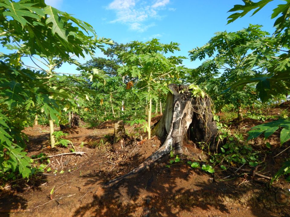

New deforestation hotspots point the finger at my favourite fruit I love Terra-i, but today I hate it. A lot. The system uses satellite images to track deforestation in the Amazon in near-realtime. It’s extremely accurate: if a bunch of trees come down somewhere – no matter how remote – Terra-i picks it up. Cool, right? Not today. CIAT’s Louis Reymondin, the system’s chief architect, dropped the bombshell over coffee: it looks as though hundreds of hectares of rainforest in Peru are being trashed by… papaya.


The production of geospatial data related to land-use and land cover changes by governments and civil society organizations has vastly increased during the last decade. Going beyond the valuable information (location, rates and absolute values of changes) provided by these datasets, it is important to have a better understanding of the spatial configurations and composition of the detected change areas at multiple spatial resolutions and time periods. Alejandro Coca-Castro’s research is aiming to map types of spatial deforestation patterns in the Amazon rainforest through the integration of landscape fragmentation metrics and data mining techniques. The research will contribute to the understanding of two deforestation datasets (Terra-i and GFC) and is part of his master dissertation at King’s College London. This blog post highlights Alejandro’s research methodology, preliminary findings and challenges.


Ecuador is recognized as one of the biodiverse hotspots on earth, underneath the Amazon rainforest lies the country’s oil reservoir. With the oil companies and cleared routes come settlers, therefore more and more of this diverse rainforest is being cut down. Since the oil concerns entered the Ecuadorian Amazon 45 years ago, they keep exploring and exploiting the area. The Terra-i detections reveal a total habitat loss of 87,525 Ha, 16,943 Ha (19%) is part of protected areas, between January 2004 and February 2015.