
San Vicente del Caguán, Colombia’s #1 deforestation hotspot


Terra-i numbers point to San Vicente del Caguán as first in the list of municipalities with highest deforestation rates in Colombia. Will it also be on top of the list of priorities to achieve the commitments made by Colombia during the COP 21?
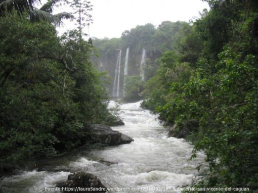
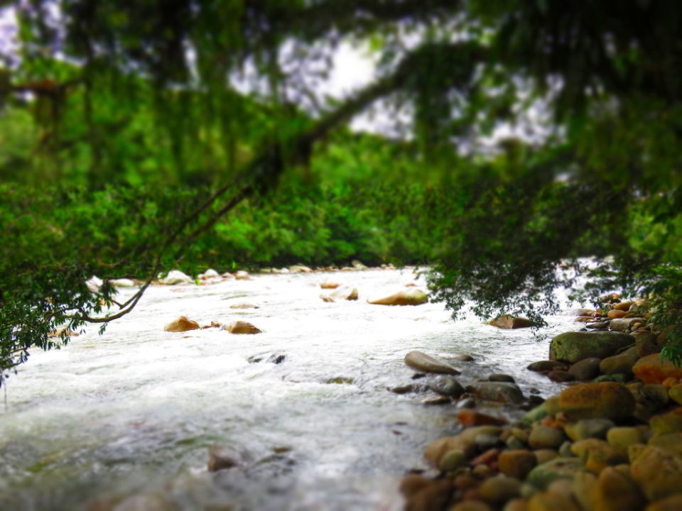
San Vicente del Caguan river.
San Vicente del Caguan is a municipality located in the southeast of Colombia that belongs to Caquetá department. Encompassing an area of nearly 1.8 millions hectares, its population reached 67.994 inhabitants in 2010, over two thirds of which are rural. Located 150 Km away from Florencia, the capital city of the department, this municipality has been one of the most seriously affected by the Colombian armed conflict.
In a project to evaluate ecosystems services in the Colombian Amazon, we mapped key zones for water availability and human footprint, and how those areas are affected by deforestation. For this purpose WaterWorld (www.policysupport.org/waterworld) -- A tool developed by King's College London with the lead of Dr. Mark Mulligan -- was used to better understand of hydrological resources, hydrological processes and the risk assessment due to changes in land use, among others [2]. This policy support system is based on the FIESTA Model (Fog Interception for the Enhancement of Streamflow in Tropical Areas) [1].
The frequent loss of forest increases flood risks. Furthermore, it can result in sudden shifts in river flow, generating high discharge due to rainfall [3]. The degradation of land cover can also directly affect water quality [4].
Water availability is the water volume that is produced, and results from the balance between rainfall and evaporation. Figure 1 shows that zones of high water availability have been recurrently affected by loss of vegetation cover. 33.6% of Terra-i detections are located in zones where water availability is high, corresponding to a deforested area of 20.387 hectares. This implies a future impact on water regulation and also on the water flows to urban centers, in addition to the impact that deforestation can cause on other activities such as irrigation.
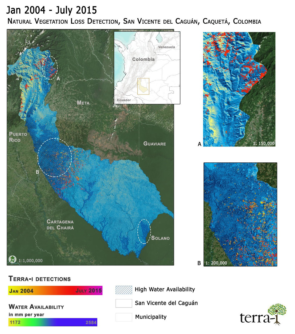
Figure 1. Terra-i detections map (January 2004 - July 2015), and water availability for San Vicente del Caguan.
Terra-i data (Figure 2) shows a total of 60.625 hectares of natural cover loss between 2004 and 2015 in the municipality, indicating an annual rate of cover loss in the period mentioned of 0.26%, the highest rate among all municipalities of Colombia.[1] The highest deforestation peak was reached in 2013, with an approximately 22.800 hectares registered as lost. Later years have shown decreasing deforestation, trends that should be maintained.
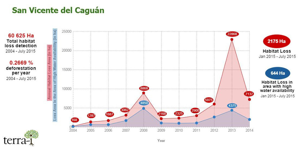
Figure 2.Annual deforestation with focus in areas with high water availability
Figures 2 and 3 also display the evolution of cover loss per year, focusing on the areas lost inside zones with high water availability. The area of high water availability has an extension of 312.080 hectares, with 6.5% of this area having been deforested since 2004. By 2008, 8.868 hectares were deforested, with 4.850 hectares of this area inside high hydrological availability zones. This latest period suffered deforestation in affected areas that are important for water provision. Furthermore, Figure 3 exposes how a large part of deforestation occurs inside key areas for water supply.
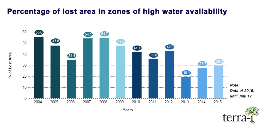
Figure 3. Percentage of deforested area inside the areas of high water Availability.
Water quality is also affected by human activities such as deforestation. In the map below (Figure 4) high values of affected water quality are seen in the Amazonian Piedmont, as well as in areas presenting high deforestation rates.
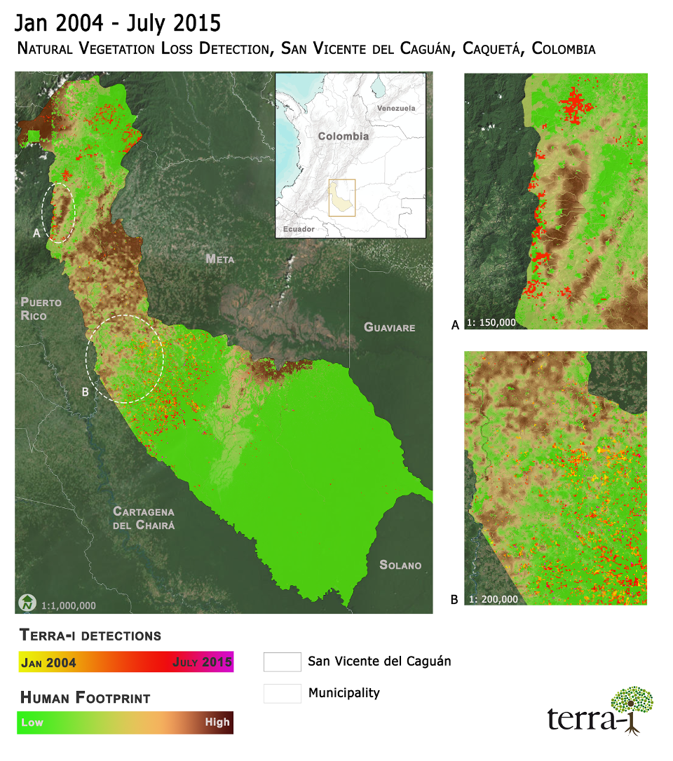
Figure 4. Human footprint on water quality
San Vicente del Caguan is a municipality that provides substantial water ecosystem service. However, as observed in the previous figures, deforestation and water pollution in rural areas are affecting its natural capital considerably. It is important to take actions that help to mitigate deforestation and to lessen environmental impacts of land use change in this municipality.
Several weeks ago, during the COP21 held in Paris, Colombia committed to reducing deforestation to 0 by 2030. This very important challenge comes with other initiatives that aim to conserve biodiversity and ecosystem services, including initiatives are to establish 3,5 million hectares of new protected areas. Furthermore, Norway, Germany and the United Kingdom promised nearly US$100 million to Colombia, to reduce deforestation and degradation of the Amazon. Therefore, the future for San Vicente del Caguan and in general for the Colombian Amazon seems to be promising.
References
1. Mulligan, M., and Burke, S. (2005). FIESTA Fog Interception for the Enhancement of Streamflow in Tropical Areas. Technical Report for AMBIOTEK contribution to DfID FRP R7991. [Online] Available at: http://www.ambiotek.com/Fiesta.
2. Mulligan, M. (2013) SimTerra: A consistent global gridded database of environmental properties for spatial modelling. http://www.policysupport.org/simterra [basado en Sexton, J. O., Song, X.-P., Feng, M., Noojipady, P., Anand, A., Huang, C., Kim, D.-H., Collins, K.M., Channan, S., DiMiceli, C., Townshend, J.R.G. (2013). Global, 30-m resolution continuous fields of tree cover: Landsat-based rescaling of MODIS Vegetation Continuous Fields with lidar-based estimates of error. International Journal of Digital Earth.
3. Bruijnzeel, L.A., Mulligan, M. and Scatena, F.S (2010) Hydrometeorology of tropical montane cloud forests: Emerging patterns. Hydrological Processes. 25:3 465-498.
4. Frank O. Masese, Phillip O. Raburu, Benjamin N. Mwasi and Lazare Etiegni (2012). Effects of Deforestation on Water Resources: Integrating Science and Community Perspectives in the Sondu-Miriu River Basin, Kenya, New Advances and Contributions to Forestry Research, Dr. Dr. Andrew A. Oteng-Amoako (Ed.), ISBN: 978- 953-51-0529-9, InTech.
Blog post by: Oscar Bautista (Terra-i CIAT) and Jairo Guerrero (Ecosystem and Earth Observation Analyst, WWF - Colombia), Map and Figures edition by Bernadette Menzinger (Terra-i CIAT).
English version prepared with help of Glenn Hyman (CIAT).


IDENTIFICACIÓN DE CAUSAS DE PÉRDIDA DE COBERTURA VEGETAL EN LAS ÁREAS DE INTERVENCIÓN DE LA ACTIVIDAD GOBERNANZA EN ECOSISTEMAS, MEDIOS DE VIDA Y AGUA (USAID/GEMA) EN EL OCCIDENTE DE HONDURAS


MAPEO DE COBERTURAS DE LA TIERRA PARA EL 2017, EN EL OCCIDENTE HONDUREÑO SOBRE ÁREAS DE INTERVENCIÓN DE LA ACTIVIDAD GOBERNANZA EN ECOSISTEMAS, MEDIOS DE VIDA Y AGUA (USAID/GEMA)


CUANTIFICACIÓN DE LA DEFORESTACIÓN EN LAS ÁREAS DE INTERVENCIÓN DE LA ACTIVIDAD GOBERNANZA EN ECOSISTEMAS, MEDIOS DE VIDA Y AGUA (USAID/GEMA) EN EL OCCIDENTE DE HONDURAS


An international team of scientists*, involving entomologists, conservation biologists, agro-ecologists and geographers, has just revealed how on-farm insect biological control can slow the pace of tropical deforestation and avert biodiversity loss on a macro-scale. The case study concerns biological control of the invasive mealybug Phenacoccus manihoti with the introduced host-specific parasitic wasp Anagyrus lopezi in Southeast Asia. The results of this study have just been published in Communications Biology – Nature.


CIAT and the Terra-i team are pleased to announce the publication of a new study in Paraquaria Natural, the most prestigious journal in Paraguay dedicated to biodiversity and the conservation of nature.

New deforestation hotspots point the finger at my favourite fruit I love Terra-i, but today I hate it. A lot. The system uses satellite images to track deforestation in the Amazon in near-realtime. It’s extremely accurate: if a bunch of trees come down somewhere – no matter how remote – Terra-i picks it up. Cool, right? Not today. CIAT’s Louis Reymondin, the system’s chief architect, dropped the bombshell over coffee: it looks as though hundreds of hectares of rainforest in Peru are being trashed by… papaya.


The production of geospatial data related to land-use and land cover changes by governments and civil society organizations has vastly increased during the last decade. Going beyond the valuable information (location, rates and absolute values of changes) provided by these datasets, it is important to have a better understanding of the spatial configurations and composition of the detected change areas at multiple spatial resolutions and time periods. Alejandro Coca-Castro’s research is aiming to map types of spatial deforestation patterns in the Amazon rainforest through the integration of landscape fragmentation metrics and data mining techniques. The research will contribute to the understanding of two deforestation datasets (Terra-i and GFC) and is part of his master dissertation at King’s College London. This blog post highlights Alejandro’s research methodology, preliminary findings and challenges.


Ecuador is recognized as one of the biodiverse hotspots on earth, underneath the Amazon rainforest lies the country’s oil reservoir. With the oil companies and cleared routes come settlers, therefore more and more of this diverse rainforest is being cut down. Since the oil concerns entered the Ecuadorian Amazon 45 years ago, they keep exploring and exploiting the area. The Terra-i detections reveal a total habitat loss of 87,525 Ha, 16,943 Ha (19%) is part of protected areas, between January 2004 and February 2015.


The Terra-i team together with CRS El Salvador under the Raices project carried out a virtual workshop through the teams platform to technicians from the Ministry of Environment and Natural Resources, CARITAS, Universidad El Salvador, CENTA, about the Mapping of land cover using remote sensors and open source tools such as GEE, SEPAL and QGIS- Plugin Semi Automatic Classification.


Near real-time vegetation loss detection in Southwestern Ethiopia: calibration, validation, and implementation of the Terra-i system


The Alliance of Bioversity International and the International Center for Tropical Agriculture (CIAT) (the Alliance) conducted a training for local stakeholders on the use of Terra-i as part of the collaboration with the Netherlands Development Organisation – SNV in the Coffee Agroforestry and Forest Enhancement for REDD+ (CAFÉ-REDD) Project.


IDENTIFICACIÓN DE CAUSAS DE PÉRDIDA DE COBERTURA VEGETAL EN LAS ÁREAS DE INTERVENCIÓN DE LA ACTIVIDAD GOBERNANZA EN ECOSISTEMAS, MEDIOS DE VIDA Y AGUA (USAID/GEMA) EN EL OCCIDENTE DE HONDURAS
MAPEO DE COBERTURAS DE LA TIERRA PARA EL 2017, EN EL OCCIDENTE HONDUREÑO SOBRE ÁREAS DE INTERVENCIÓN DE LA ACTIVIDAD GOBERNANZA EN ECOSISTEMAS, MEDIOS DE VIDA Y AGUA (USAID/GEMA)
CUANTIFICACIÓN DE LA DEFORESTACIÓN EN LAS ÁREAS DE INTERVENCIÓN DE LA ACTIVIDAD GOBERNANZA EN ECOSISTEMAS, MEDIOS DE VIDA Y AGUA (USAID/GEMA) EN EL OCCIDENTE DE HONDURAS
An international team of scientists*, involving entomologists, conservation biologists, agro-ecologists and geographers, has just revealed how on-farm insect biological control can slow the pace of tropical deforestation and avert biodiversity loss on a macro-scale. The case study concerns biological control of the invasive mealybug Phenacoccus manihoti with the introduced host-specific parasitic wasp Anagyrus lopezi in Southeast Asia. The results of this study have just been published in Communications Biology – Nature.


From May 8-12, 2017, the Terra-i team, together with staff from the DGOTA of Peru's Ministry of Environment, carried out the first field validation of vegetative land cover changes detected during Terra-i monitoring for 2016 and 2017, using the technology UAV. This work was carried out under the framework of the project “Sustainable Amazonian Landscapes”. The team carried out over-flights with a Phantom 3 advanced rotor drone and a fixed-wing Ebee drone in seven townships of Yurimaguas. The objective of this work was to recognize the dynamics of land cover and land use changes in the region while at the same time to validate the accuracy of the detections of forest loss being monitored by Terra-i in Yurimaguas.
CIAT and the Terra-i team are pleased to announce the publication of a new study in Paraquaria Natural, the most prestigious journal in Paraguay dedicated to biodiversity and the conservation of nature.


The Terra-i team has worked hard on renovating Terra-i’s website since early this year. A set of new features on the website provides interactive contents and facilitates adaptation to the mobile devices of our users. The fresh website was developed using the latest update of an open-source, Java-based web system, Magnolia CMS 5.4.4. This update was customized to add different categories of interaction such as news, vegetation cover changes, and information, among others.


Globally more than 1 billion people depend on forests for their livelihoods. Forests play a crucial role in climate regulation, ecosystem services provision and regulation, water supply, carbon storage and many other functions that support biodiversity. Currently the global rate of deforestation is substantial, and there is a growing need for timely, spatially explicit data that flag natural vegetation changes due to human activities.
New deforestation hotspots point the finger at my favourite fruit I love Terra-i, but today I hate it. A lot. The system uses satellite images to track deforestation in the Amazon in near-realtime. It’s extremely accurate: if a bunch of trees come down somewhere – no matter how remote – Terra-i picks it up. Cool, right? Not today. CIAT’s Louis Reymondin, the system’s chief architect, dropped the bombshell over coffee: it looks as though hundreds of hectares of rainforest in Peru are being trashed by… papaya.


The latest update of Terra-i has been used with the Co$ting Nature ecosystem services assessment tool to understand the impacts of recent forest loss in Colombia on biodiversity and ecosystem services.
The production of geospatial data related to land-use and land cover changes by governments and civil society organizations has vastly increased during the last decade. Going beyond the valuable information (location, rates and absolute values of changes) provided by these datasets, it is important to have a better understanding of the spatial configurations and composition of the detected change areas at multiple spatial resolutions and time periods. Alejandro Coca-Castro’s research is aiming to map types of spatial deforestation patterns in the Amazon rainforest through the integration of landscape fragmentation metrics and data mining techniques. The research will contribute to the understanding of two deforestation datasets (Terra-i and GFC) and is part of his master dissertation at King’s College London. This blog post highlights Alejandro’s research methodology, preliminary findings and challenges.
Ecuador is recognized as one of the biodiverse hotspots on earth, underneath the Amazon rainforest lies the country’s oil reservoir. With the oil companies and cleared routes come settlers, therefore more and more of this diverse rainforest is being cut down. Since the oil concerns entered the Ecuadorian Amazon 45 years ago, they keep exploring and exploiting the area. The Terra-i detections reveal a total habitat loss of 87,525 Ha, 16,943 Ha (19%) is part of protected areas, between January 2004 and February 2015.